Trail Walking Le Valtin - Les Hirschsteine - Photo

Les Hirschsteine

© OpenStreetMap contributors
Length
Length
16.1 km
Max alt
Max alt
1281 m
Uphill gradient
Uphill gradient
684 m
Km-Effort
Km-Effort  
25 km
Min alt
Min alt
1049 m
Downhill gradient
Downhill gradient
682 m
Boucle
Boucle
Yes
Creation date :
2014-12-10 00:00:00.0
Updated on :
2014-12-10 00:00:00.0

(1 Reviews)

Walking
Walking
6h28
Difficulty : Difficult

Scan this QR Code to open this trail in the SityTrail application

FREE GPS app for hiking

Logo SityTrail SityTrail

IGN / Geographical institutes

Download SityTrail from the App Store Download SityTrail from Google Play

Logo SityTrail SityTrail World

The world is yours!

Download SityTrail from the App Store Download SityTrail from Google Play Download SityTrail on Huawei AppGallery

About

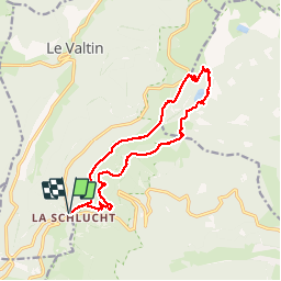
Trail Walking of 16.1 km to be discovered at Grand Est, Vosges, Le Valtin. This trail is proposed by VacheKiri67.

Description

Faite le 08/06/2014 avec notre fils de 9 ans, son copain Marc et ses parents.
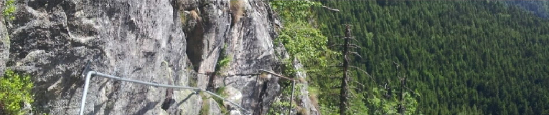
Le sentier des Hirschsteine triangle jaune est très escarpé (échelles, gardes-corps) et est indiqué déconseillé aux non-initiés. A emprunter par temps sec avec de bonnes chaussures.

Elevation profile

Photos

Points of interest

Point of interest Soultzeren - Point 18 - Photo
VacheKiri67
SOULTZEREN 

Positioning

Country:
France
Region :
Grand Est
Department/Province :
Vosges
Municipality :
Le Valtin
Location:
Unknown
Start:(UTM)
352730 ; 5325308 (32U) N.

Comments

Please log in to post a review or rate the element


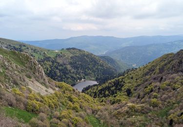
Parcours alpin de très grande beauté. Bonnes chaussures indispensables.


Trails nearby

Trail Walking Stosswihr - Tour du belvedere avec le passage sur les crêtes  - Photo
Walking
ocepee

Walking

Very easy
(2)
Stosswihr, Grand Est, Haut-Rhin, France
8.5 km | 0 m-effort
2h 28min
Yes
Trail Other activity Soultzeren - Totom 4 lacs - Photo
Other activity
dinozore

Other activity

Medium
(1)
Soultzeren, Grand Est, Haut-Rhin, France
15.6 km | 26 km-effort
4h 37min
Yes
Trail Walking La Bresse - Les 5 lacs autour du Hohneck - Photo
Walking
tiene

Walking

Very difficult
(1)
La Bresse, Grand Est, Vosges, France
21 km | 36 km-effort
7h 21min
Yes
Trail Walking La Bresse - Du Hohneck au Kastelberg par les Spietzkoepfe et le Sentier des Névées - Photo
Walking
tracegps

Walking

Very difficult
(3)
La Bresse, Grand Est, Vosges, France
7.6 km | 13.7 km-effort
3h 30min
Yes
Trail Walking Soultzeren - Tanet-Gazon du faing par lac vert et retour sommet du Tanet - Photo
Walking
ride-in-Elsass

Walking

Medium
(1)
Soultzeren, Grand Est, Haut-Rhin, France
10 km | 15.6 km-effort
4h 24min
Yes
Trail Snowshoes Le Valtin - raquettes  - Photo
Snowshoes
vathi54

Snowshoes

Very easy
(1)
Le Valtin, Grand Est, Vosges, France
6.6 km | 9.4 km-effort
3h 8min
No
Trail Walking Stosswihr - Le cirque glaciaire du Frankenthal - Sentier des Roches -Gps - Photo
Walking
GUIDE
Desrumaux

Walking

Difficult
(3)
Stosswihr, Grand Est, Haut-Rhin, France
9 km | 16.1 km-effort
4h 10min
Yes
Trail Walking Metzeral - 2023-05-20 Marche Lac Fischboedle vers Firstmiss - Photo
Walking
GUIDE
holtzv

Walking

Medium
Metzeral, Grand Est, Haut-Rhin, France
21 km | 37 km-effort
8h 20min
No
Trail On foot La Bresse - Tour d’Artimont - Photo
On foot
PRO

On foot

Easy
La Bresse, Grand Est, Vosges, France
4.6 km | 6.8 km-effort
1h 32min
Yes


Close
My subscriptions